Maps
![]()
![]()
Maps
Detail from Warton-with-Lindeth Tithe Map 1846
The production of digital photographs of the seven Tithe Maps for the seven townships of the Mourholme area was undertaken with the assistance of Lancashire Archives. The schedules for each map were transcribed by the volunteers of the Lancashire Place Name Survey. The original maps and schedules are available to view at Lancashire Archives, details here:
https://www.lancashire.gov.uk/libraries-and-archives/archives-and-record-office/
The Mourholme LHS is very grateful to Lancashire Archives for their assistance in making this project possible. We also remember Margaret Bainbridge, a former member, whose generous legacy enabled this digital photography to be undertaken professionally.
Click on any of the map images below to open a large scale copy of that township's tithe map in a new window. The maps are quite large file sizes, so depending on the speed of your broadband, may take a little time to upload.
Each field on the map has a number. Open the corresponding Schedule for details of each plot's owner, occupant, field name, use and size (in particular refer to the Field Number column). Two options are presented below each map:
1. The Schedule as was drawn up by the Tithe Commissioners - in alphabetical order of the landowner surname. This is most useful when you want to see the total holdings of any given landowner. This enabled the Commissioners to more easily calculate the total cash tithe to be paid by each landowner.
2. Ordered by Plot Number. This is most useful when you want to look up the details for any plot numbered on the map. For most research this will be the most used option.
Warton-with Lindeth
Schedule: DRB 1/195
Ordered by Plot Number
Borwick
Schedule: DRB 1/23
Ordered by Plot Number

Carnforth
Schedule: DRB 1/36
Ordered by Plot Number
Priest Hutton
Schedule: DRB 1/156
Ordered by Plot Number
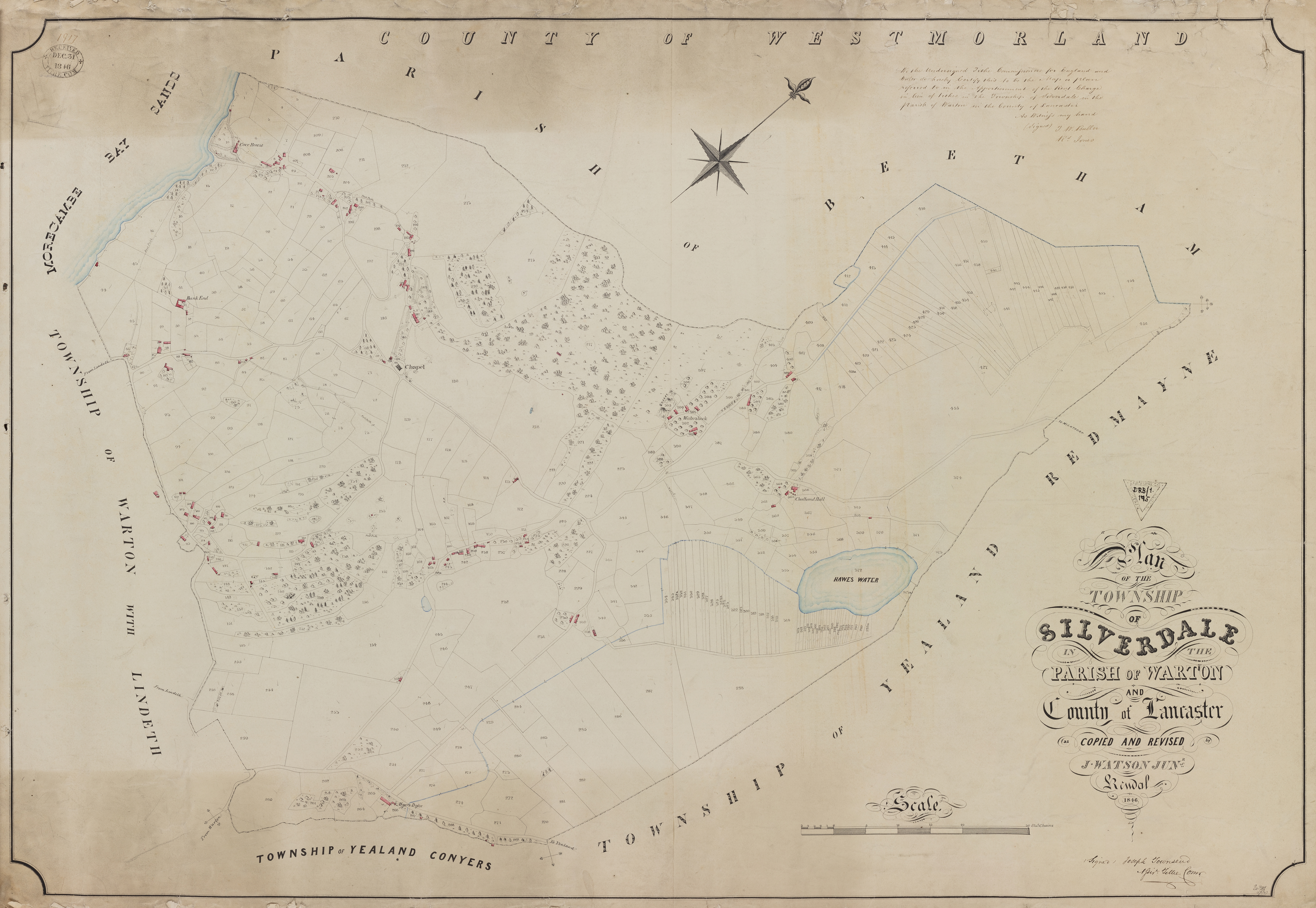
Silverdale
Schedule: DRB 1/175
Ordered by Plot Number
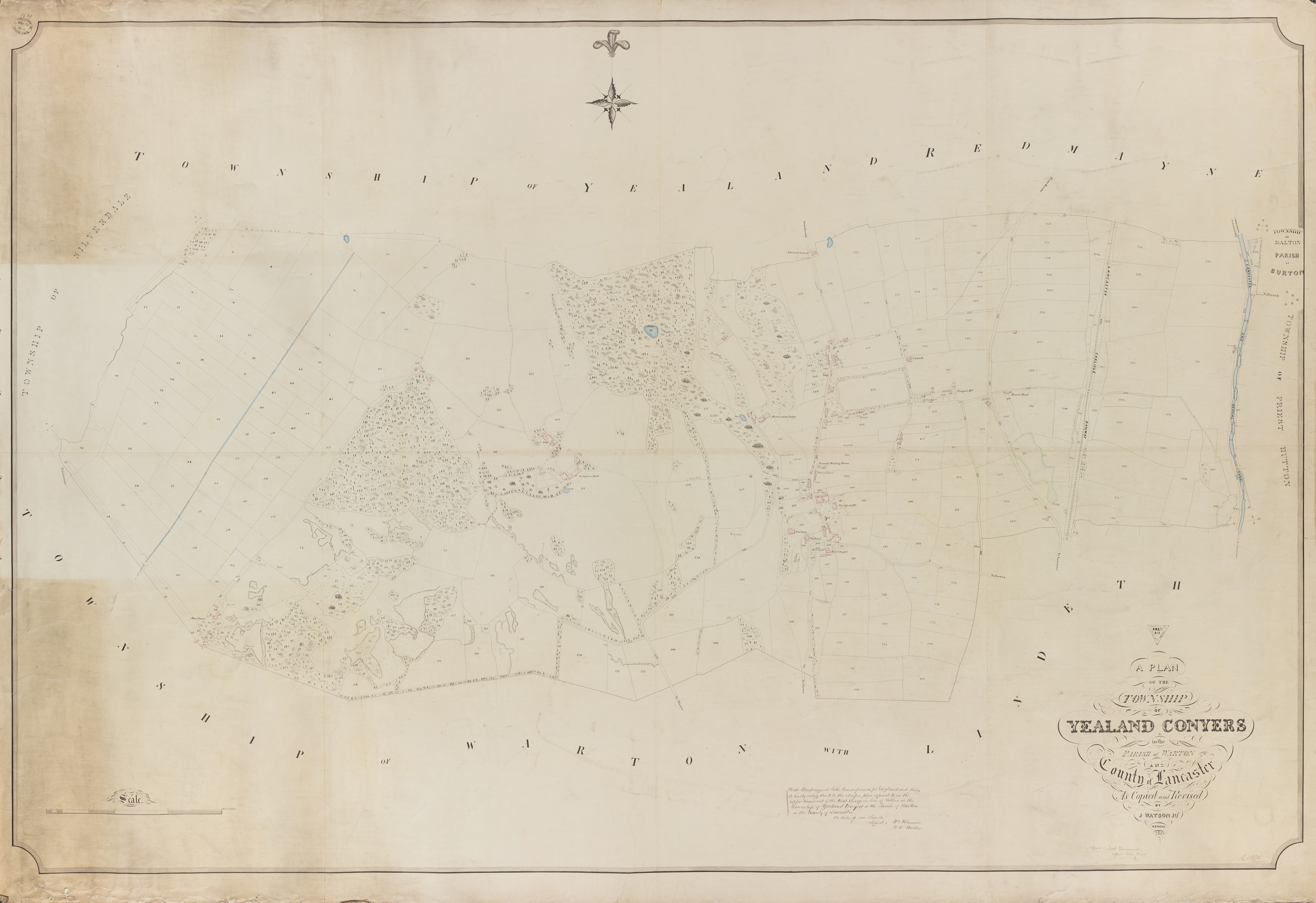
Yealand Conyers
Schedule: DRB 1/219
Ordered by Plot Number

Yealand Redmayne
Schedule: DRB 1/220
Ordered by Plot Number
The Tithe Maps are large scale maps. Each field or piece of land featured on a tithe map carries a number. By cross-referencing this number with the corresponding number under the Field Number column in the Tithe Schedule, we can learn: Tithe Maps, produced for many (but not all) areas of England and Wales between 1841 and 1851, were a necessary means to the rationalising of the ancient system of giving one tenth of the production of any parcel of land to the church. By the time of the Tithe Commutation Act 1836 tithes were often paid to landlords, and sometimes in cash rather than kind. These Tithe Maps and Schedules stipulated the tithes to be paid henceforth from each field and property. For a fuller description of this history: https://en.wikipedia.org/wiki/Tithe_map
- Landowner name
- The occupier
- Field name and/or description of the property
- The state of cultivation of the field
- The size (acres, roods and perches)
- Tithe owner - i.e. to whom the tithe is paid.
As a result, tithe maps and schedules are an invaluable resource to local historians and genealogists, providing a snapshot of the detailed map of the land, the names of owners and occupiers, and a short description of the use of that land.
Other Map Resources
maps.nls.uk - The National Library of Scotland has a full collection of historic Ordnance Survey maps which can be viewed online.
lancaster.libguides.com/Lancashirehistoricmaps - digital copies of historic Lancashire maps - mostly from the collection of Dr Ian Saunders.